Beautiful Laya – Gasa Trek
Trekking
Tour Duration: 19 Days /18 Nights
Difficulty Level: Very Hard
This is a 14-days Trek, an extension of the Jumolhari Trek and offers diverse flora and fauna, including a good opportunity to spot Blue Sheep, Takins and the Blue Poppy (Bhutan’s national flower). It introduces you to the unusual culture of the Layap people (The Nomadic people of Upper Himalayas bordering Tibet) and offers a stop at a natural hot spring in Gasa. It is a popular Trek. Highest point is 4115 Meter.
Book the trip now
Itinerary
Arrive Paro 2280 meters (By Druk Air). The flight into Paro on our national carrier, Druk Air, is a befitting introduction to the spectacular beauty of our country. In clear weather, magnificent views of the world’s highest peaks, give way to the lush green Paro valley as you land. Your Bhutanese escort from Omkara Tours & Travels will greet you on arrival, and then drive you the short distance to the Hotel. After breakfast, visit the Ta Dzong, an ancient watchtower, which now houses the National Museum. Below the museum is the Paro Rimpung Dzong, the center of civil and religious authority in this valley. A short walk takes you to the base of the dzong and across a traditional cantilevered, covered bridge. A short distance further is one of the innumerable archery grounds (Archery is the national sport of Bhutan). If we are lucky, we may catch a match in action. Dinner and over night in Hotel.
Paro 2280 meters: Excursion to Taktsang Monastery. A very special day, with an excursion to view the spectacular Taktsang (Tiger’s Nest) monastery – After breakfast a short drive takes us to Satsam Chorten, from there a 2 hour horse ride till the viewpoint point of the monastery. The trail climbs through beautiful pine forest, many of the trees festooned with Spanish moss, and an occasional grove of fluttering prayer flags. We stop for a rest and light refreshments at the Taktsang Jakhang (cafeteria) and then walk a short distance until we see, clearly and seemingly within reach, Taktsang monastery. Built in the 1600s, this incredible monastery clings to the edge of a sheer rock cliff that plunges 900 m into the valley below. Legend has it that Guru Padmasambhava, the tantric mystic who brought Buddhism to Bhutan, landed here on the back of a flying tiger. Lunch will be served at the cafeteria, followed by a short walk to Satsam Chorten. In the evening, drive to the ruins of the Drukgyal Dzong 16 km up the valley. Built in 1647 by the great Shabdrung Ngawang Namgyal, father and unifier of medieval Bhutan, the dzong was destroyed by accidental fire and left in ruins as an evocative reminder of the great victories it was built to commemorate. Explore the ramparts and on a clear day experience an unforgettable view of Mt. Jhomolhari (7,314 m). On the way back, visit Kichu Lhakhang that was built in 659 by the Tibetan King Srongsen Gampo. The evening ends with a walk through Paro’s main shopping district. Dinner and over night in Hotel.
Paro – Shana (Start of Trek). Altitude 2,850 m; Distance 17 Km; Time 5 – 6 hours, 360 meters ascent, 80 meters descent. Day 03. Paro – Shana (Start of Trek): Our trek to Shana starts at Drukgyal Dzong at 2580 meters following the Paro river and we pass cultivated fields and tiny picturesque villages. The forests are alive with numerous birds and brightly coloured butterflies. Dinner and overnight at camp Shana.
Shana – Thangthangka. Altitude: 3610 m; Distance 22 Km; Time 7 – 8 hours, Ascent: 770 meters, Descent: 10 meters. The trail follows the river through a heavily forested area with a few isolated farmhouses. It narrows and closes in and the trail winds up and down along the drainage. We pass a junction enroute, where another path leads north over the Tremo La to Tibet. Camp is in a meadow with a stone shelter.
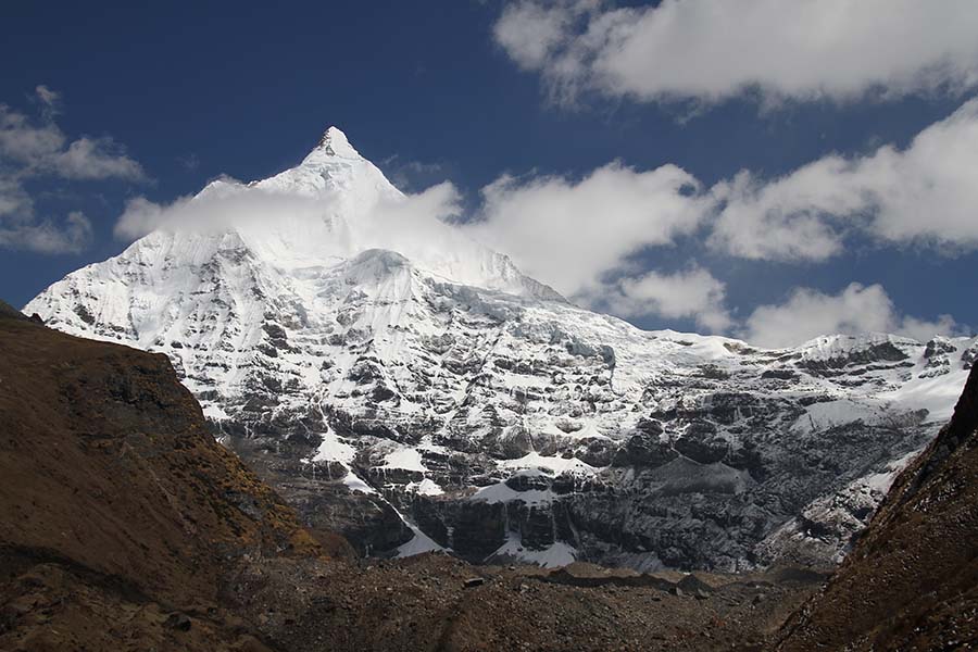
Thangthangka – Jangothang: Altitude: 4080 m; Distance 19 Kms; Time 5 – 6 hours, 480 meters Ascent. In the morning, after passing a small army post, the trail slowly leaves the forest line and gradually climbs into a beautiful valley, passing Tegethang, a winter home of yak herdsmen. Lunch will be served in one of these huts. Lots of yaks will be seen today before we arrive at the Jhomolhari base camp (4,115 m). High mountains overlook the camp and visible nearby are the ruins of an old fortress used to guard Bhutan against Tibetan invasions. Dinner and overnight in camp.
Jangothang: Rest day at Jangothang, enjoy the superb view all around. For Day hikes, you have 3 options on this day at Jangothang.
1. Hike to Jumolhari Glacier which is around 4 ½ hours (Back and forth)
2. Hike to Jichu Drake Glacier which is around 3 hours (Back and Forth)
3. Walk up the mountain between Jumolhari and Jichu Drake, the summit is at 5200 meters with a great view of both the mountains. This is 8 hours (Back and forth)
Jangothang – Lingshi. Altitude 4000 m; Distance 17 kms; Time 6 – 7 hours. A good day’s walk today with spectacular views of the Jhomolhari, Jichu Drake and the Tserim Gang. We start climbing straight away and after some 3 to 4 hours reach the Nyelela pass (4,700 m). After the pass we descend to a circular hut just below Lingshi, where we camp. Coming down from Lingshi we obtain our first views of the truly mystical Dzong atop a high hill. Dinner and overnight in camp.
Lingshi – Chebisa. Camp site at an altitude of 3880 m; Distance 10 kms; Time 5 – 6 hours, Ascent: 280 meters, Descent: 410 meters. This is a magical day. After we leave Lingshi, we gently climb gently to reach another delightful village, Gom Yu, which is set right below a 300 m cliff. Another hour walk brings us to a lovely little valley with a huge waterfall at one end of the Shangri La village of Chebisa, where we camp by the side of the river. The walk is an easy one. Dinner and overnight in camp.
Chebisa – Shomuthang. Camp at Altitude 4220 m; Distance17 kms; Time 6-7 hours, Ascent 890 meters, Descent 540 meters. We start with quite a stiff climb through high pastures up the Gokula pass (4,320 m) before we drop through forests of dwarf rhododendron. We climb gradually and head down to the camp near a riverbed.
Shomuthang – Robluthang. Camp at Altitude: 4,160 m; Distance 18 kms; Time 6 – 7 hours, Ascent 700 meters, Descent 760 meters. A long haul over the Jarela pass at 4,640 m where we once again get stunning views of the Himalayan Mountains above us. We drop steeply down a forest trail to the Tsarigathang valley, where herds of Takin roam, then cross a knee deep river before climbing up Robluthang where we camp.
Robluthang – Lemithang. Camp at Altitude 4,140 meters; Distance: 19 kms; Time 6-7 hours. Ascent 850 meters, Descent 870 meters. This is one of the hardest days of the trek. We climb slowly up to Shinchela pass at 4,870 m. and are rewarded with stunning views of mountains, including the spectacular Gang Chen Ta at the head of the valley. On a clear day practically all the mountains on the northern border are visible. Eagles, griffin vultures, blue sheep and yaks abound in this area. We descend down to camp on a lovely spot by the riverbank.
Lemithang – Laya. Camp at Altitude3840m; Distance10 kms; Time 4-5hours, Ascent 60 meters, Descent 340 meters. We walk along the river, one of the tributaries of the Mochu and through a forest of rhododendron and silver fir and then enter the village of Laya. The people of Laya are famous for their vertical stripe yak hair clothing and their strange conical bamboo hats. The women wear their hair long and with great deal of turquoise and jade jewelry. The features of the people are even more Tibetan/ Mongolian than the Bhutanese who live in the central valleys The rest of the day is spent at leisure or visiting village houses and mixing with the villagers. Good views of the Masagang and the other peaks.
Laya (Halt). We have a rest day at Laya and an opportunity to meet the local people.
Laya – Koena. Camp at Altitude 3050 meters; Distance19 kms; Time 6-7 hours, 260 meters Ascent, Descent 1070 meters. The rail winds along the river valley offers breathtaking views of the crashing river, feeder streams and waterfalls. Over night in camp.
Koena – Gasa Tsachu. Camp at Altitude: 2,638 m; Distance 14 kms; Time: 6-7 hours, Ascent 900 meters, Descent 1710 meters. We gradually climb up to Balela pass at 3,740 m and then descend to Gasa village. The first sight of the Gasa Dzong perched on the hillside over the village is one of the sights of the trip. We then drop steeply down to the river for an hour and camp near the Hot Spring a chance for a good, hot bath.
Gasa Tsachu – Goen Damji – Punakha (End of Trek). Gasa – Damji (18 kms), 5-6 hours, Ascent 470 meters, Descent 280 meters. After the climb away from Gasa Tsachu the trail winds through rolling hillsides with the vista of fields, villages and forests of oak and pine. Gasa Dzong will be visible behind you glued to the valley wall, seeming afloat in space. The trail descends from the high agricultural benches above the Mochu into a lush semi-tropical gorge filled with banana trees, creepers and the sight of an occasional monkey. The vehicle will pick you up at Damji and drive to Punakha (2 hours). Dinner and over night in Hotel.
Punakha -Thimphu (72 Kms). After breakfast, visit Punakha Dzong built in 1637 by Shabdrung Ngawang Namgyal and is situated between Pho Chu (Male river) and Mo Chu (Female river). For many years until the time of the second king, it served as the seat of the Government. The construction of the Dzong was foretold by Guru Rimpoche, who predicted, “…a person named Namgyal will arrive at a hill that looks like an elephantâ€. There was a smaller building here called Dzong Chu (Small Dzong) that housed a statue of Buddha. It is said that Shabdrung ordered the architect, Zowe Palep, to sleep in front of the statue, while Palep was sleeping, the Shabdrung took him in his dreams to Zangtopelri and showed him the palace of Guru Rimpoche. From his vision, the architect conceived the design for the new Dzong, which in keeping with the tradition, was never committed to paper. The Dzong was named Druk Pungthang Dechen Phodrang (Palace of Great Happiness). The war materials captured during the battle with Tibetans are preserved here. Punakha is still the winter residence of Je-Khenpo and King Jigme Dorji Wangchuk convened the new national Assembly here in 1952. After lunch, drive to Thimphu. Enroute visit Chimi Lhakhang also called Temple of Fertility built by Lama Drukpa kuenley in 17th century. Dinner and overnight in Hotel.
Thimphu sightseeing. The day begins with a visit to the National Memorial Chorten (1974) built in honour of our late King Jigme Dorji Wangchuk and the Dupthop Lhakhang one of the few surviving nunneries in Bhutan. We then visit the National Library, stocked with ancient Buddhist manuscripts, and the Painting School where traditional art is still kept alive through instructions in the art of painting Thangkas (sacred Buddhist religious scrolls). After lunch, visit to the Tallest Statue of Buddha in the world, witness Archery Match. Other highlights include a visit to the Tashichho Dzong, seat of the national government and the Central Monastic Body, including the summer residence of the Je Khenpo (Chief Abbot of Bhutan). The Tashichho Dzong is open to visitors only in winter when the Je Khenpo and the Monk Body move to Punakha the ancient winter capital of Bhutan and finally visit the Handicrafts Emporium followed by shopping for souvenirs in the shops of Thimphu. Dinner and overnight in Hotel.
Departure: Early Morning, drive to the airport and farewell