Jomolhari Trek
Trekking
Tour Duration: 14 Days /13 Nights
Difficulty Level: Normal
Jomolhari Trek is the most popular trekking routes in Bhutan. With altitude differences of 2,500m and nearly 5,000m it offers a wide range of landscapes, fauna and flora. The highlight of this trek is the spectacular view of Mount Jomolhari from Jomolhari base camp (Jangothang)
Book the trip now
Itinerary
You will be received by our representative at Paro International Airport and welcomed to Bhutan. You will be shifted to Hotel in Paro. A welcome drink to freshen you up and check in to your room. After rest, local tour of Paro. Based ont he time of the day, local sight seeing can be done. Spend the evening in Paro town strolling. A nice sumptuous dinner and a good night in the hotel.
After breakfast, move to the base of the hill for the Tigers Nest hike. The hike to Taktsang monastery (Tigers nest monastery). The hike which is all the way uphill takes about 2 to 3 hours through pine forests. The monastery which clings to a huge granite cliff 800 meters from the Paro valley is one of the most famous site in the world. It is believed that the great saint Padmasambhava or Guru Rinpoche came in the 7th century on a flying tigress and meditated in a cave for 3 years 3 months and 3 days. The demons were subdued who were trying to stop the spread of Buddhism and converted the people of Paro valley into Buddhists.
GUNITSAWA VILLAGE – SHARNA ZAMPA 40mins, 80 m descent, camp altitude 2,850 m. This trek begins at Gunitsawa Village were you pass the army post. At the army checkpost your trek permit (provided by your tour operator) will be checked and endorsed. The campsite is on the opposite side of the river, not far from Gunitsawa.
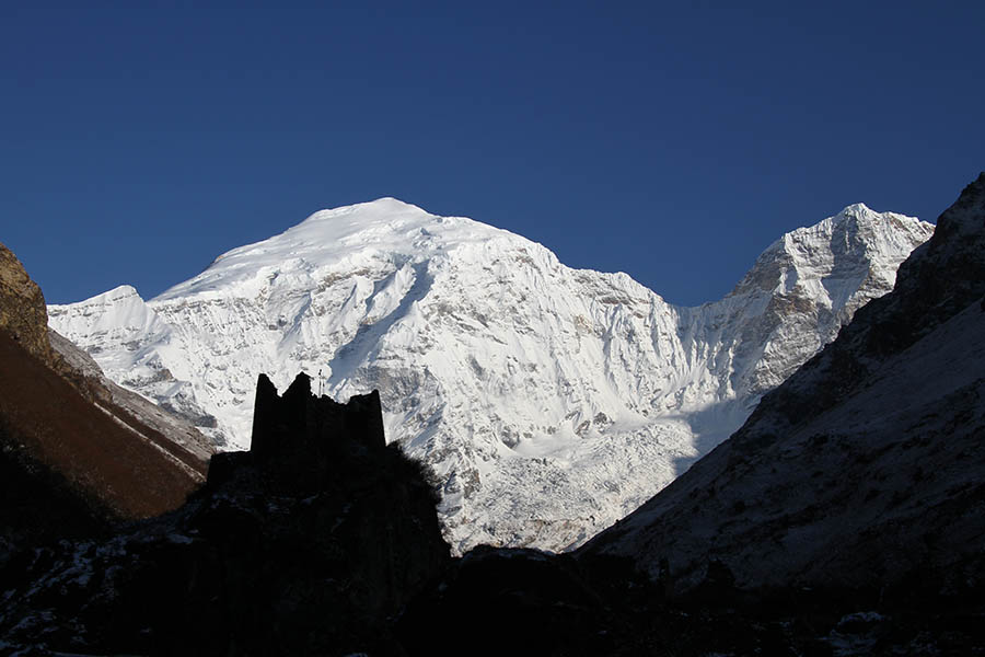
SHARNA ZAMPA - THANGTHANGKHA Distance 22 km, 7-8 hours, 770 m ascent, 10 m descent, camp altitude 3,610 m. On this long day, the trail continues with lots of small ups and downs. After going uphill through the river valley the valley finally narrows gradually to a mere path which descends to a meadow where a camp will be set up. From here, if weather permits, you will have the first great view of Mt. Jomolhari.
THANGTHANGKHA – JANGOTHANG Distance 19 km, 5-6 hours, 480 m ascent, camp altitude 4,080 m. If you did not see Mt. Jomolhari the previous evening, you will still have a chance to get a great view early this morning. This morning the trek continues up the Paro Chhu valley which widens into patches of alpine meadow and scanty growths of forest. You will cross an army checkpoint along the way and enjoy a spectacular view of high mountain ridges and snow-capped peaks. In this area yaks and their herder’s homes become a regular feature of the landscape. Passing the villages Soe, Takethang and Dangochang is another asset on this day. After reaching Jangothang, one of the most beautiful campsites of the Himalayas, you will again have a spectacular view of Mount Jomolhari.
JANGOTHANG HALT The rest day in Jangothang provides plenty of possibilities for day hikes with great views of lakes and snow capped mountains such as Jomolhari and Jichu Drake. There are good chances to spot some blue sheep on the upper slopes of the valley. Jangothang is a perfect environment for your acclimatization. You can also trek up to Tosoh or hike around the area. There are good short hiking trails in three directions. Jomolhari and its subsidiary mountain chains lie directly west, Jichu Drake to the north and there are a number of unclimbed peaks to the east.
JANGOTHANG – LINGSHI Distance 16km, six to seven hours, 810m ascent, 1,090m descent, camp altitude 3,800m. The trail leads to a last settlement in the valley and drops to the Paro Chhu. Passing the lake of Tshophu (4,380m) you will climb up steeply to Bhonte La pass at 4,890 m, the highest point of this trek route. Reaching the Dhumzo Chhu river, you trek downstream passing the few houses of Soi Yaktsa (Dhumzo) to arrive at your camp soon after.
LINGSHI – SHODU Distance 22km, eight to nine hours, 940m ascent, 920m descent, camp altitude 4,080m. The trail climbs up to the Yelila pass at an altitude of 4,930m. From the pass, on a clear day you will get an excellent view of Jumolhari, Tserimgang and Masanggang. The trek from the pass to the campsite at Shodu is a steep downhill.
SHODU – BARSHONG Distance 16km, five to six hours, 250m ascent, 670m descent, camp altitude 3,710m. The trail follows the Thimphu Chhu through rhododendron forests, past beautiful waterfalls along the way. The valley narrows till the path takes to the slopes and gradually ascends to the ruins of Barshong Dzong.
BARSHONG – DOLAM KENCHO Distance 15km, four to six hours, 290m ascent, 640m descent, camp altitude 3,320m. The trail descends down to the Thimphu Chhu river valley, through dense forests of rhododendron, birch, conifer, maples and bamboos and then ascends to pasture lands. The camp is in a meadow.
DOLAM KENCHO – DODENA Distance 8km, three to four hours, 500m ascent, 930m descent. The trail continues through forested areas winding up and down and through a small pass. Langurs (monkeys) can be seen along the way. In Dodena, you will exit the Jigme Dorji National Park and reach the road head next to a impressive cantilever bridge.
FINAL DAY of the Trek. The trek finishes at the beautiful Cherri Monastery, while it is a 40 min hike to the monastery it is well worth it. Move to hotel and checkin. Relax in Hotel and freshen up. Visit Thimphu town in the evening. Spend a pleasant evening in Thimphu. Night halt in Thimphu
After breakfast, local sigh seeing of Thimphu. Spend the day sigh seeing and return back to Hotel for a nice cultural program hosted for you. A sumptuous dinner and peaceful night at your hotel.
Travel to paro international airport where Omkara Tours will give you a nice farewell to your next destination